Potentially the crater. We will find out.
Have you ever wondered if those giant craters you have only heard about online, or only ever seen in pictures, were real? Have you ever stopped and asked yourself about them?
One argument is that you cannot see the crater as an empty hole today because it has filled with water since 2014. That is a fair case to make.
But we have something similar to the Wayback Machine for satellite imagery. Tools like Google Earth allow you to go back through historical imagery and see what a location looked like before it changed.
Well, way back.
So why is this crater so difficult to find now?
On the historical imagery, when I look at 2014, the map becomes very glitchy and the resolution is extremely low. The imagery does not allow me to clearly see the crater around the time of its reported creation.
See the chnages in the terrain after many years. Do you notice anythign different?
Might this be because the hole shown in the aerial imagery actually looks smaller from above?
This could certainly be the case. A feature that looks enormous in a photograph taken close to the ground can look much less obvious from a satellite. The angle, resolution, image quality, and surrounding landscape all affect what you can see.
But something else caught my attention.
It is almost like Google does not want you to see what was there before, or even what is there now.
I want to be careful with that statement. I do not have evidence that Google intentionally removed or concealed the crater. What I do have is a strange-looking collection of imagery that makes the location difficult to investigate.
You can also notice that this area of Siberia has many craters and circular lakes. So the likelihood of this particular crater filling with water is possible, especially when we see similar water-filled features throughout the surrounding landscape.
Well, we do not exactly know if those other lakes and craters formed through the same process as the one we are looking for.
That distinction matters.
A circular lake does not automatically mean an explosive gas crater formed there. Different geological and permafrost processes can produce similar-looking features.
Still, the imagery itself is interesting.
It is quite odd how there are columns and patches that look like different dates of aerial imagery were patched together, creating one map. Can we verify this?
Yes, we can.
Satellite and aerial mapping systems often use mosaics. A mosaic combines multiple images to create a larger, continuous map. Those images do not necessarily come from the same date, and different sections can have different resolution, lighting, color, or image quality.
That means what looks like one photograph from above might actually be several images stitched together.
So who is to say that mosaic stitching does not leave out accurate imagery from a particular period?
Again, I am not saying anyone intentionally removed the crater. I am asking whether the way historical imagery is assembled could make an environmental feature harder to find.
Could this be why we cannot clearly see the crater and instead have to rely on images taken by scientists who were physically there?
And then there is the geology.
The same region of Siberia contains extensive natural gas reserves and geological systems beneath the permafrost. So I started thinking about the crater less as some unexplained hole and more as the result of processes happening beneath the surface.
The region has gas pockets that build pressure beneath the ground. The Earth also has gaseous processes occurring underneath layers of rock, soil, ice, and permafrost. It would not be strange for those processes to eventually break through the surface if enough pressure builds beneath a weakened layer.
That is where the story gets more interesting.
Researchers have referred to these features as gas emission craters, or GECs. A 2025 study by Hellevang and colleagues examined the processes behind these large Siberian eruptions.
The researchers agree that pressurized methane plays a major role in the formation of these craters. However, their research suggests that processes occurring only within the permafrost probably do not provide enough gas or pressure to explain the size and force of the eruptions.
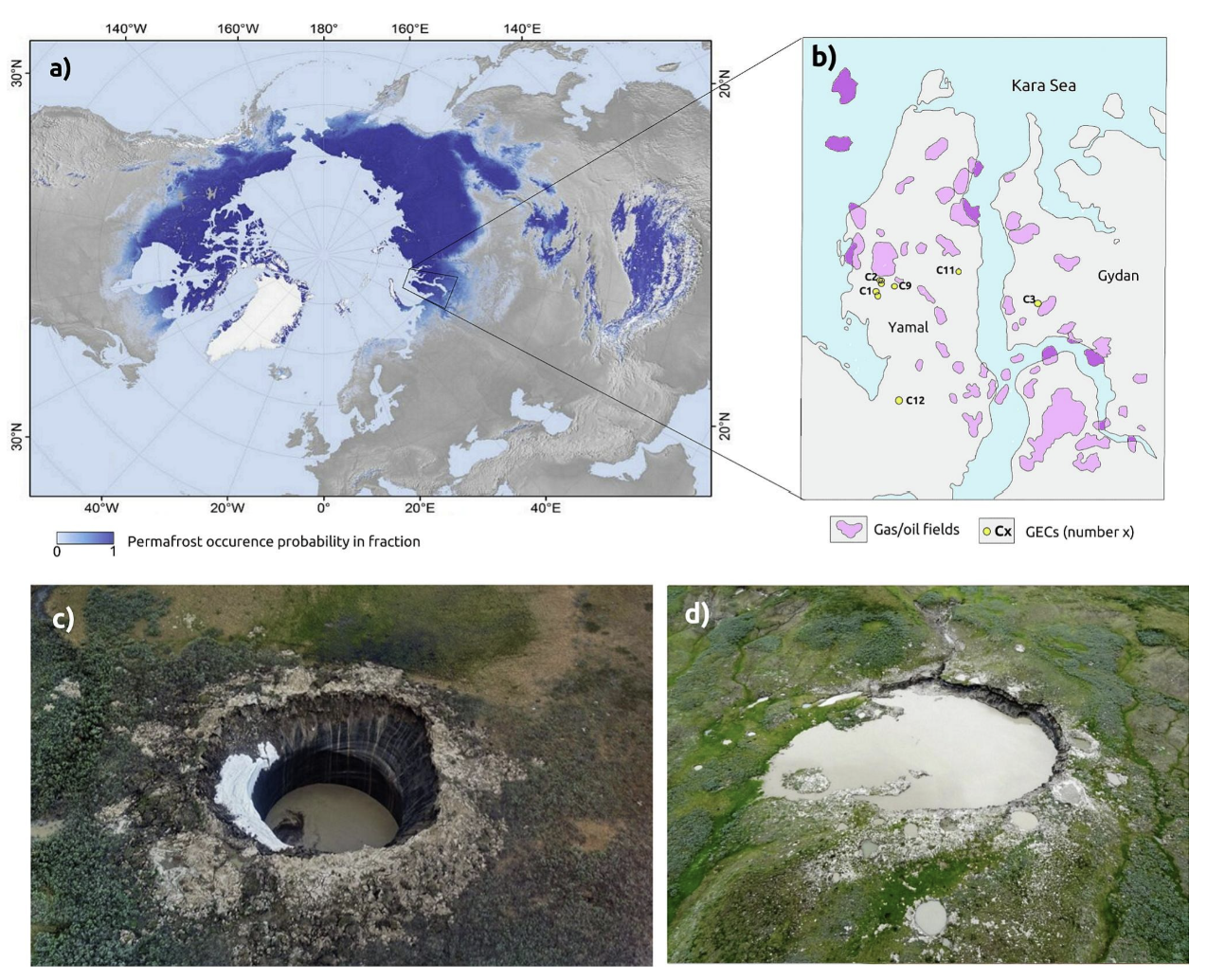
A) Probability map of Arctic permafrost (modified from Obu et al., 2019); B) seven discovered GECs (yellow circles) and gas/oil fields at the Yamal and Gydan peninsulas; C) and D) GECs C1 and C2. (Hellevang et al., Sci. of the Total Env., 2025)
Instead, they point toward deeper geological processes.
Heat and natural gas from below the permafrost may move upward through faults in the underlying rock. This is important because the Yamal and Gydan peninsulas sit above one of the world's major natural gas regions. Gas from these deeper systems could accumulate beneath the permafrost and create substantial pressure below the surface (Hellevang et al., 2025).
Climate change still plays a role.
The researchers propose that warming conditions can weaken and thin the permafrost that acts as a lid above these pressurized gas systems. As the frozen ground changes, the surface becomes more vulnerable to pressure building underneath it.
So climate change might not be creating all of the gas or pressure responsible for these eruptions. Instead, warming conditions could be helping create the conditions for an eruption to reach the surface (Hellevang et al., 2025).
That explanation makes sense when you look at the landscape as a whole.
The same area has numerous lakes, permafrost features, gas deposits, and evidence of changing ground conditions. The Siberian permafrost is not a completely static layer sitting on top of the Earth. There are geological processes happening underneath it all the time.
In short, this is really not as mysterious as it seems.
It is a natural process that has happened before and could happen again. The difference is that climate change is accelerating changes to the permafrost system, potentially creating conditions where these events become easier to expose at the surface.
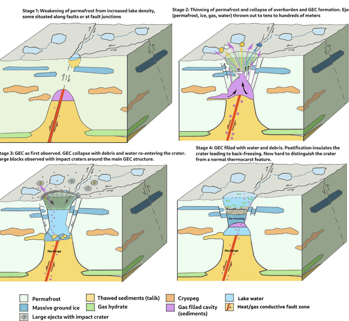
Hellevang et al., Sci. of the Total Env., 2025
And if another crater forms, we might not recognize what happened forever.
A newly formed crater can collect water. The walls can collapse. Sediment can accumulate. Vegetation can begin growing around the depression. Over time, the original crater can start looking like an ordinary lake.
Hellevang and colleagues describe a post-formation stage where surface processes gradually mask the original gas emission crater. This means an older crater might eventually become difficult to distinguish from other lakes and depressions in the landscape (Hellevang et al., 2025).
So perhaps the question is not only, “Where did the crater go?”
Perhaps the better question is, “How long does a crater remain recognizable after it forms?”
When we look at a satellite map years later, we are not necessarily looking at the landscape as it existed when the event happened. We are looking at what survived the changes that happened afterward.
That makes the search for this particular crater more difficult.
It also makes the satellite imagery worth questioning.
The strange patches and changes in resolution do not prove anything was intentionally hidden. They do show how difficult it is to use historical satellite imagery as a perfect record of a rapidly changing landscape.
The crater might have been there. The crater might have filled with water. The imagery might not have captured it clearly. And the landscape might have already begun covering up the evidence.
I wonder if, in the same way that this region has gas pockets that seemingly explode, the Earth also has gaseous processes underneath its layers that we still do not fully understand.
With enough pressure, and with a weakening layer of permafrost above it, those processes do not need anything supernatural to reach the surface.
They only need the right conditions. So no, this does not require Superman to have climbed out of the ground. And it probably does not require the Leviathan either. The Earth already has enough going on underneath our feet.
References
Hellevang, H., Ippach, M. R., Westermann, S., & Nooraiepour, M. (2025). Formation of giant Siberian gas emission craters. Science of the Total Environment, 995, 180042. https://doi.org/10.1016/j.scitotenv.2025.180042
Google Earth Help. (n.d.). Historical imagery and imagery availability.