Christin Bratton - Environmental Scientist
brattonmsb91@aol.com
(716) 367-1771
I conduct on-the-ground environmental inspections, review projects for compliance, document site conditions, and support land stewardship and safety decisions in rugged, outdoor environments.
Thank you for your time and consideration!
Web Based Mapping/ Field Research & Reporting
I apply GIS and publicly available environmental datasets to support field research, site assessment, and reporting. My mapping work includes brownfield analysis, land use review, and spatial context development used to complement field observations and improve clarity in environmental documentation.
Wetland Monitoring:
Lake Erie Nutrient Loading and Climate Risk Brief Maumee River and Western Basin Focus
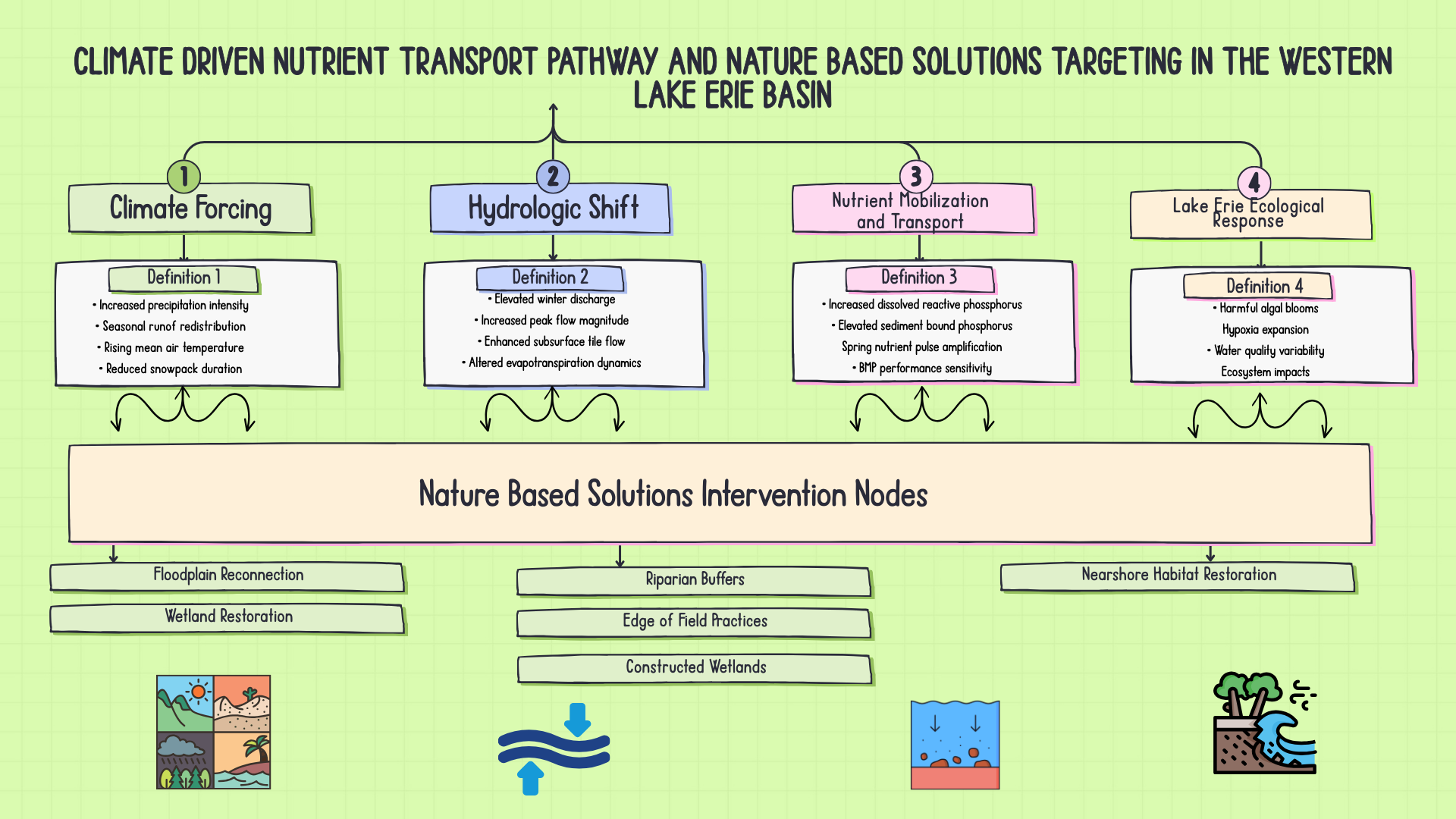
This technical brief synthesizes peer reviewed climate modeling literature and watershed scale nutrient research to evaluate climate driven risk in the Western Lake Erie Basin. The analysis integrates precipitation projections, hydrologic response, nutrient transport dynamics, and nature based intervention strategy to inform adaptive management and regulatory planning.
Climate driven shifts in precipitation intensity and seasonal runoff are altering nutrient transport timing and magnitude in the Maumee, Raisin, Sandusky, and Grand watersheds. This brief translates modeling findings into field level implications and restoration strategy targeting.
What This Demonstrates
• Climate scenario interpretation
• Watershed systems analysis
• GIS informed risk framing
• Nature based solutions targeting
• Regulatory integration literacy
Systems Diagram
The Research
I design and use original field reporting logs to document site conditions, access, safety observations, and environmental impacts in a consistent, repeatable format (to your right). These logs support accurate reporting, clear communication, and reliable decision-making during and after field work. In my current role, we use internal templates.
Field Logs and Tempalates
Field work and site assessments
This work focuses on visiting sites, assessing conditions, noting access and environmental issues, and turning those observations into clear reports. Examples here include a Splash Pad site report I managed and a Florida-based editorial that covered the project.
This piece links to a project I covered that involved reporting on environmental, access, and community issues at North Anclote Park Pier. My review process included reviewing public source materials, analyzing site conditions, assessing shoreline and access impacts. Tools used included web-based ArcGIS for the following Layers (EO 11990 Wetland, EO 11988 Floodplain, Coastal Barrier Resource Act (CBRA), Coastal Zone Management Act (CZMA), State Historic Preservation Office (SHPO).
Related Project Review
Certifications
CPR/First Aid certified and prepared for sustained field operations and variable outdoor conditions.